Navigate here 👇
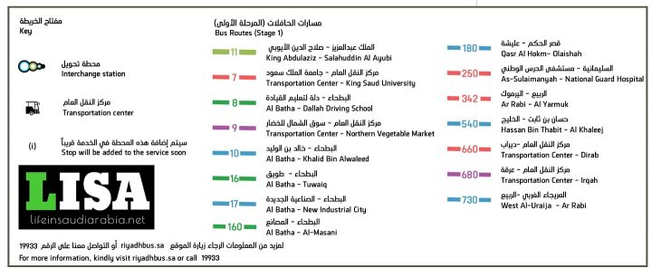
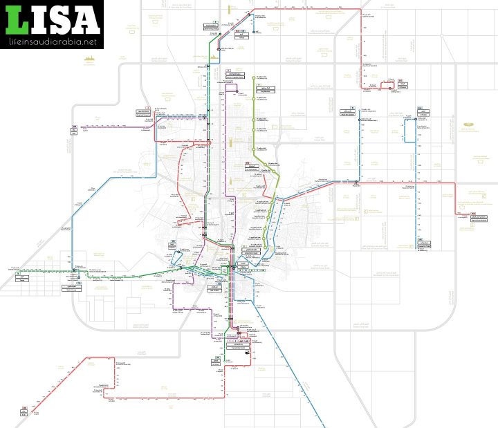
All important districts and places in Riyadh are connected through 33 Metro City Bus routes, as shown in the PDF map below.
Riyadh Metro City Bus Timings
The Metro City buses provide service in Riyadh from 5:00 am until 12:00 am.
Never pay the full price🏷️; join the 📢Saudi Coupon Codes group and get sales updates and discount codes in one place.
Riyadh Metro City Bus Routes Map
All important districts and places of Riyadh are connected with each other through 33 Metro City Bus routes. Here are the details of each route. You can download the Riyadh Metro Bus Routes map in PDF from this link.
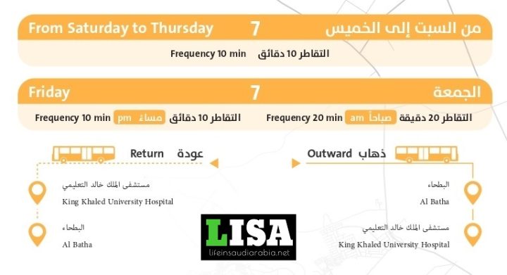
Route 07
Route, 07 of Riyadh Metro City Bus, connects Al Batha to King Saudi University and takes the following stops;
- Frequency on Weekdays: every 10 minutes.
- Frequency on Friday: every 20 minutes.
- Al Batha ➜ Ahwal Madani ➜ Ministry of Foreign Affairs ➜ Al-Nasiriyah ➜ King Khalid Grand Mosque ➜ King Khaled Eye Specialist Hospital ➜ King Saudi University.
- King Saudi University ➜ King Khaled Eye Specialist Hospital ➜ King Khalid Grand Mosque ➜ AL Nasiriyah ➜ Ministry of Foreign Affairs ➜ Civil Affairs ➜ Al Batha.
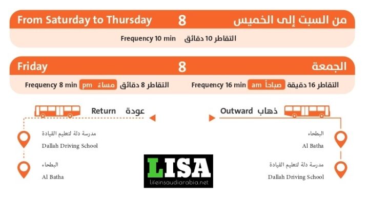
Route 08
Route 08 of Riyadh Metro City Bus connects Al Batha to Dallah Driving School and takes the following stops;
- Frequency on Weekdays: every 10 minutes.
- Frequency on Friday: every 16 minutes.
- Al Batha ➜ Ahwal Madani ➜ Ministry of Foreign Affairs ➜ King Faisal Specialist Hospital ➜ Euromarch markets ➜ King Abdullah Financial District ➜ Dallah Driving School.
- Dallah Driving School ➜ King Abdullah Financial District ➜ Euromarch markets ➜ King Faisal Specialist Hospital ➜ Ministry of Foreign Affairs ➜ Civil Affairs ➜ Al Batha.
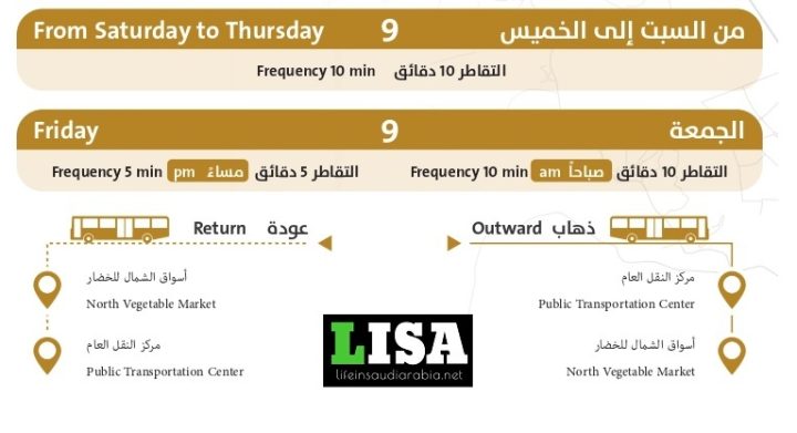
Route 09
Route 09 of Riyadh Metro City Bus connects the Public Transportation Center to North Vegetable Markets and takes the following stops;
- Frequency: Every 10 mins.
- Public Transportation Center ➜ Al Batha ➜ Chamber of Commerce ➜ Faisaliyah Tower ➜ Kingdom Tower ➜ Uwais markets ➜ North Vegetable markets.
- North Vegetable markets ➜ Uwais markets ➜ Kingdom Tower ➜ Faisaliyah Tower ➜ Chamber of Commerce ➜ Al Batha ➜ Public Transportation Center.
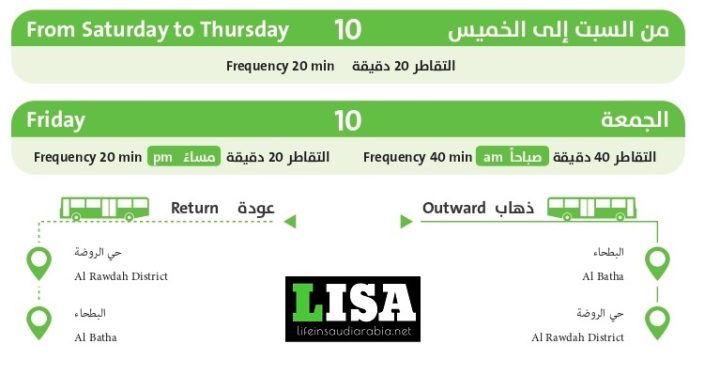
Route 10
Route 10 of Riyadh Metro City Bus connects Al Batha to Al Quds District and takes the following stops;
- Frequency on Weekdays: every 20 minutes.
- Frequency on Friday: every 40 minutes.
- Al Batha ➜ Central Post ➜ King Faisal bin Fahd Stadium ➜ Riyadh Zoo – Ministry of the National Guard ➜ Labour Office (Al Rawdah) ➜ Khalid bin Waleed.
- King Abdulaziz Public Library ➜ Royal Saudi Air Forces ➜ Security Forces Hospital ➜ King Faisal bin Fahd Stadium ➜ Central Post ➜ Al Batha.
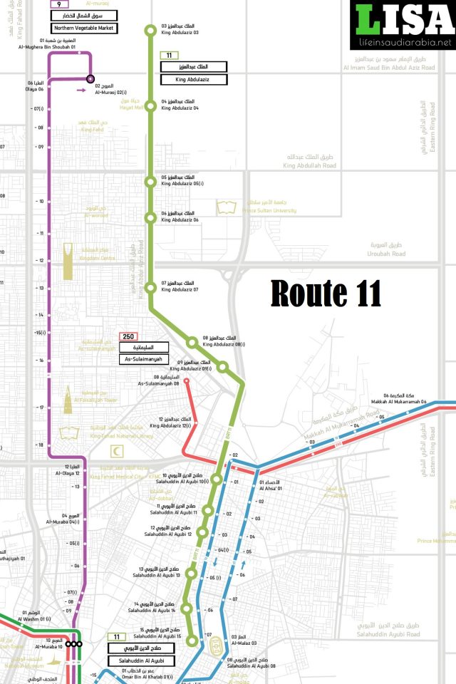
Route 11
Route 11 of Riyadh Metro City Bus connects Hayat Mall to Prince Faisal Bin Fahd Stadium.
- Hayat Mall ➜ Sahara Mall ➜ Riyadh Palace ➜ The View Mall ➜ Security Forces Hospital ➜ King Abdullah Park ➜ Prince Faisal bin Fahd Stadium.
- Prince Faisal bin Fahd Stadium ➜ King Abdullah Park ➜ Security Forces Hospital ➜ The View Mall ➜ Riyadh Palace ➜ Sahara Mall ➜ Hayat Mall.
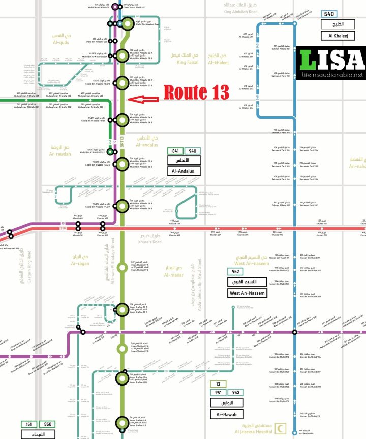
Route 13
Route 13 of Riyadh Metro City Bus connects TGI Fridays on Khalid bin Waleed Street to Sky Mall on Imam Shafi Street.
- Khalid Ibn Waleed Street ➜ TGI Fridays ➜ Al Sadhan Supermarket ➜ ElFaleh Sports ➜ Tamimi Markets ➜ Abdullah Al-Othaim Markets ➜ Riyadh Mall ➜ Khurais Road ➜ Imam Al Shafi Street ➜ V Fitness ➜ Al Yamamah Hospital ➜ Prince Mohammed Bin Abdulaziz Hospital ➜ Sky Mall.
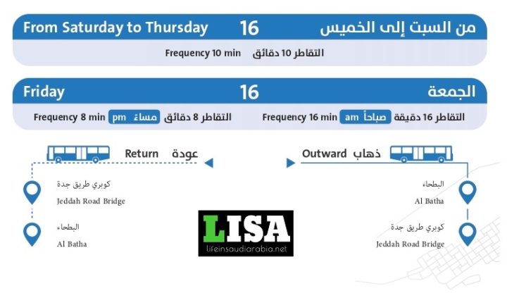
Route 16
Route 16 of Riyadh Metro City Bus connects Al Batha to Jeddah Road Bridge and takes the following stops;
- Frequency on Weekdays: every 10 minutes.
- Frequency on Friday: every 16 minutes.
- Al Batha ➜ Al Maglya shopping center ➜ King Saud Medical City ➜ Haggar School ➜ Albadeah Mall ➜ Al Nasr Club ➜ Jeddah Road Bridge.
- Jeddah Road Bridge ➜ Al Nasr Club ➜ Albadeah Mall ➜ Haggar School ➜ King Saud Medical City ➜ Al Maglya shopping center ➜ Al Batha.
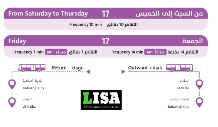
Route 17
Route 17 of Riyadh Metro City Bus connects Al Batha to Industrial City and takes the following stops;
- Frequency on Weekdays: every 10 minutes.
- Frequency on Friday: every 14 minutes.
- Al Batha ➜ Riyadh Water Tower ➜ Al-Kharj ➜ Yamama Saudi Cement Factory ➜ Convalescent hospital ➜ Saudi Cables ➜ Industrial City.
- Industrial City ➜ Kharj Housing ➜ Convalescent hospital ➜ Yamama Saudi Cement Factory ➜ Al-Kharj ➜ Ibn Sulaiman Commercial Center ➜ Al Kharj.
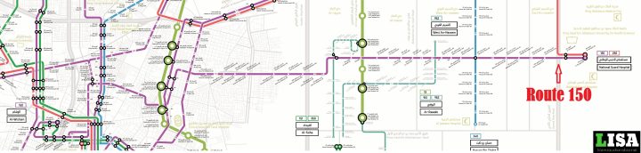
Route 150
Route 150 of Riyadh Metro City Bus connects Al-Wisham to National Guard Hospital and takes the following major stops;
- National Guard Hospital ➜ Nasseriya ➜ Prince Mohammed Bin Abdulaziz Hospital ➜ Al-Muraba ➜ Ma’Ahad Al Idarah ➜ Security Forces Hospital ➜ Omar Bin Abdulaziz ➜ Al Nahda Park ➜ Unayzah ➜ Ar-Rawabi ➜ As-Salam ➜ West An-Naseem ➜ Hassan Bin Thabit ➜ Mohammed Bin Hindi ➜ National Museum ➜ Abdullah Bin Saleem.
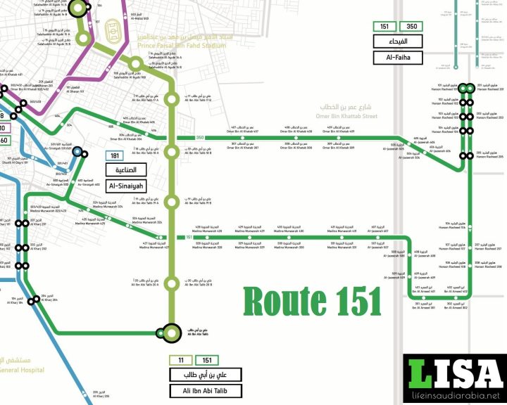
Route 151
Route 151 of Riyadh Metro City Bus connects Ali Ibn Talib street to Fahya and takes the following major stops;
- Ali Ibn Abi Talib ➜ Al Kharj ➜ Riyadh Rail Station ➜ Madina Munwarah Road ➜ As-Sinaiyah ➜ Madina Munwarah Road ➜ Al-Jazeerah Park ➜ Ibn Al Ameed ➜ Haroon Rasheed ➜ Dawak Medical Complex ➜ Boudle Al Fahya Hotel.
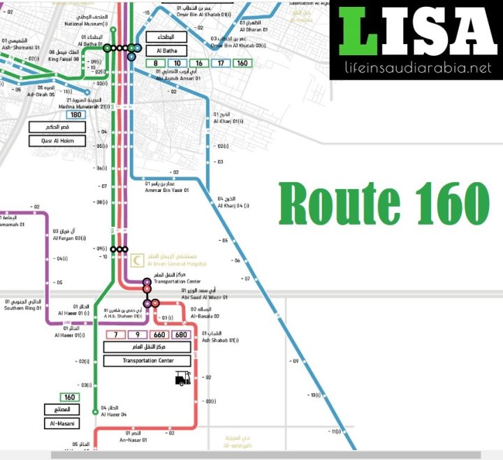
Route 160
Route 160 of Riyadh Metro City Bus connects Al Batha to Al-Masani and takes the following major stops;
- Al Batha ➜ Madina Road ➜ Al Iman General Hospital ➜ Abi Hafs bin Shaheen Road ➜ Al Haeer ➜ Al Masani.
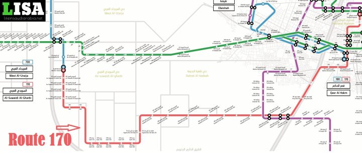
Route 170
Route 170 of Riyadh Metro City Bus connects National Museum to Public Al-Suwaidi Garden and takes the following major stops;
- National Museum ➜ King Faisal Road ➜ Al Masmak Palace Museum ➜ Madina Munwarah Road ➜ Riyadh General Court ➜ Suwaidi Al Am ➜ Ayesha Bint Abi Bakr ➜ Sadir ➜ As-Suwaidi Al-Gharbi ➜ Suwaidi Al-Gharb Public Al-Suwaidi Garden.
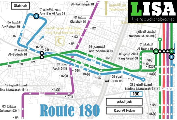
Route 180
Route 180 of Riyadh Metro City Bus connects Qasr Al Hokm to Ulaishah and takes the following major stops;
- Qasr Al Hokm ➜ Ad-Dirah ➜ Al Masmak Palace Museum ➜Ash-Shomaisi ➜ Assir Street ➜ Al Badeah ➜ Al Rafeah ➜ Amr Bin Al Aas ➜ King Saud Medical City ➜ Ulaishah Park.
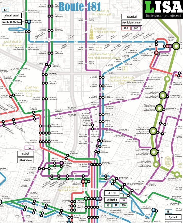
Route 181
Route 181 of Riyadh Metro City Bus connects Al-Sinaiyah to North Al-Mathar and takes the following major stops;
- Ad Dar ➜ Omar Bin Al Khatab ➜ King Fahad Medical City ➜ Riyadh Dry Port ➜ Al-Muraba ➜ Zakat, Tax and Customs Authority ➜ Al-Olaya ➜ As-Sulaimanyah ➜ Abu Dhabi Square ➜ As-Sulaimanyah ➜ Al-Olaya ➜ North Al-Mathar.
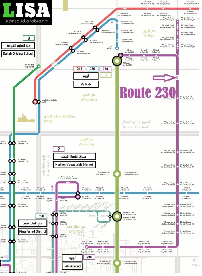
Route 230
Route 230 of Riyadh Metro City Bus connects Al-Woroud to Al-Rabi and takes the following major stops;
- King Abdullah Road ➜ Ministry of Education ➜ Abi Bakr Alsiddiq Road ➜ North Riyadh Traffic Department ➜ AlNada District Park ➜ Ar-Rabi.
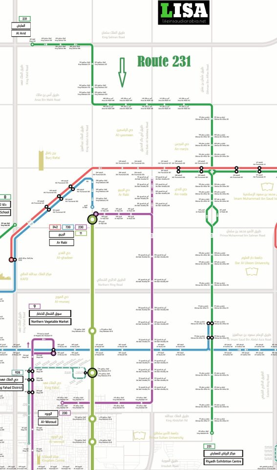
Route 231
Route 231 of Riyadh Metro City Bus connects Riyadh Exhibition Center to Al-Arid and takes the following major stops;
- Riyadh International Convention & Exhibition Center ➜ King Abdullah Road ➜ Othman Bin Affan Road ➜ Ath Thumamah ➜ Othman Bin Affan Road ➜ Al-Imam Mohammed Bin Saud University ➜ Anas Bin Malik Road ➜ King Abdulaziz Road ➜ King Salman Road ➜ Olaya.
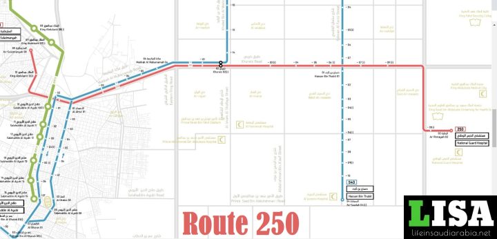
Route 250
Route 250 of Riyadh Metro City Bus connects Armed Forces Officers Club to National Guards Hospital and takes the following major stops;
- As-Sulaimanyah ➜ Armed Forces Officers Club ➜ Prince Sultan Military Medical City ➜ King Abdul Aziz Road ➜ Makkah Al Mukarramah Road ➜ Al Nahda Park ➜ Eastern Ring Road ➜ Khurais ➜ King Abdul Aziz Medical City ➜ King Abdul Aziz University for Health Sciences ➜ National Guard Hospital ➜ Al Rimayah.
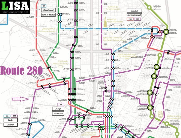
Route 280
Route 280 of Riyadh Metro City Bus connects Sulaimaniyah to Olaishah and takes the following major stops;
- Abu Dhabi Square ➜ As-Sulaimanyah ➜ Makkah Al Mukarramah Road ➜ Prince Sultan Military Medical City ➜ King Saud Road ➜ Ministry of Interior ➜ King Faisal Road ➜ King Saud Road ➜ An-Nasiriyah ➜ Ar-Rafeah ➜ Olisha Park ➜ Hudaifa Bin Al Yaman.
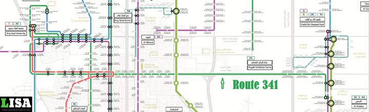
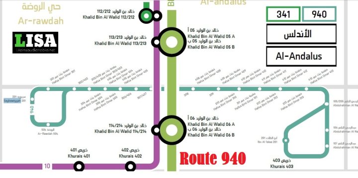
Route 341
Route 341 of Riyadh Metro City Bus connects King Saud University to Al Andulas and takes the following major stops;
- King Saud University ➜ King Abdullah Road ➜ Al Urubah ➜ Abdulrahman Al Ghafqi Rooad ➜ Khalid Bin Al Walid Road.
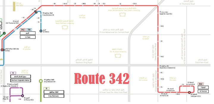
Route 342
Route 342 of Riyadh Metro City Bus connects King Abdullah Financial District to Al Yarmuk and takes the following major stops;
- King Abdullah Financial District ➜ Ath Thumamah ➜ King Abdul Aziz Road ➜ Riyadh Personal Status Court ➜ Abu Bakr Siddiq Road ➜ Othman bin Affan Road ➜ Imam Muhammad Ibn Saud Islamic University ➜ Saeed Bin Zaid ➜ Khalid Bin Al Walid ➜ Al-Hamra ➜ Al Yarmuk.
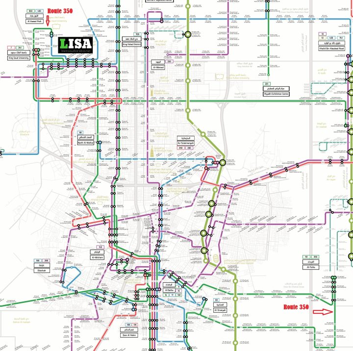
Route 350
Route 350 of Riyadh Metro City Bus is probably the longest route which connects Al-Awwal Park to Al-Fahya and takes the following major stops;
- Al Awwal Park ➜ King Saud University ➜ King Abdullah Road ➜ Ar-Raed ➜ North Al-Mathar ➜ King Faisal Specialist Hospital ➜ Al-Mathar ➜ King Khalid Road ➜ King Saud Road ➜ An-Namuthajiyah ➜ Amr Bin Al Aas Road ➜ Nasseriya Street ➜ Ministry of Foreign Affairs ➜ King Abdulaziz Road ➜ National Museum ➜ Omar Bin Al Khatab Road ➜ Al-Jazeerah ➜ Haroon Rasheed Road.
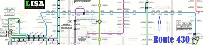
Route 430
Route 430 of Riyadh Metro City Bus connects Khalid bin Waleed Road to Al Awwal Park and takes the following major stops;
- Khalid Bin Al Walid Road ➜ Al-Hamra ➜ Al-Ezdihar ➜ Othman Bin Affan Road ➜ Al-Nuzha ➜ Al-Maseef ➜ Al-Murooj ➜ Al-Nakheel ➜ Al-Muhammadiyah ➜ King Abdullah Road ➜ Digital City ➜ King Saudi University ➜ Al-Awwal Park.
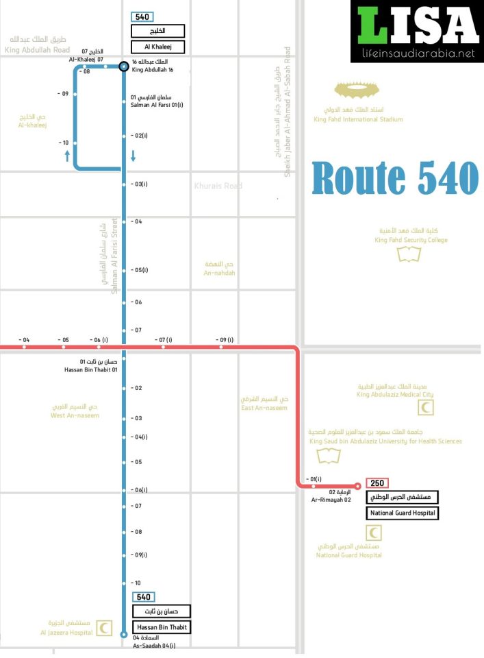
Route 540
Route 540 of Riyadh Metro City Bus connects Al Jazeera Hospital to King Abdullah Road and takes the following major stops;
- Al Jazeera Hospital ➜ Hassan Bin Thabit Road ➜ Khurais Road ➜ Salman Al Farsi Road ➜ Al-Khaleej ➜ Al Khaleej Garden➜ King Abdullah Road.
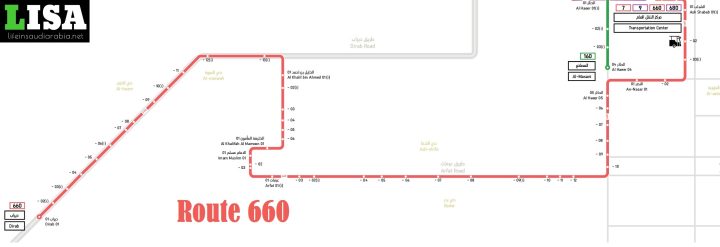
Route 660
Route 660 of Riyadh Metro City Bus connects Transportation Center to Dirab and takes the following major stops;
- Transportation Center ➜ Al-Basala ➜ Ash Shabab ➜ An-Nasar Road ➜ Al Haeer ➜ Arafat Road ➜ Imam Muslim ➜ Al Khalifah Al Mamoon ➜ Al Khalil bin Ahmed ➜ Imam Abdulrahman Alfaisal Hospital ➜ Al Marwah ➜ Dirab Road.
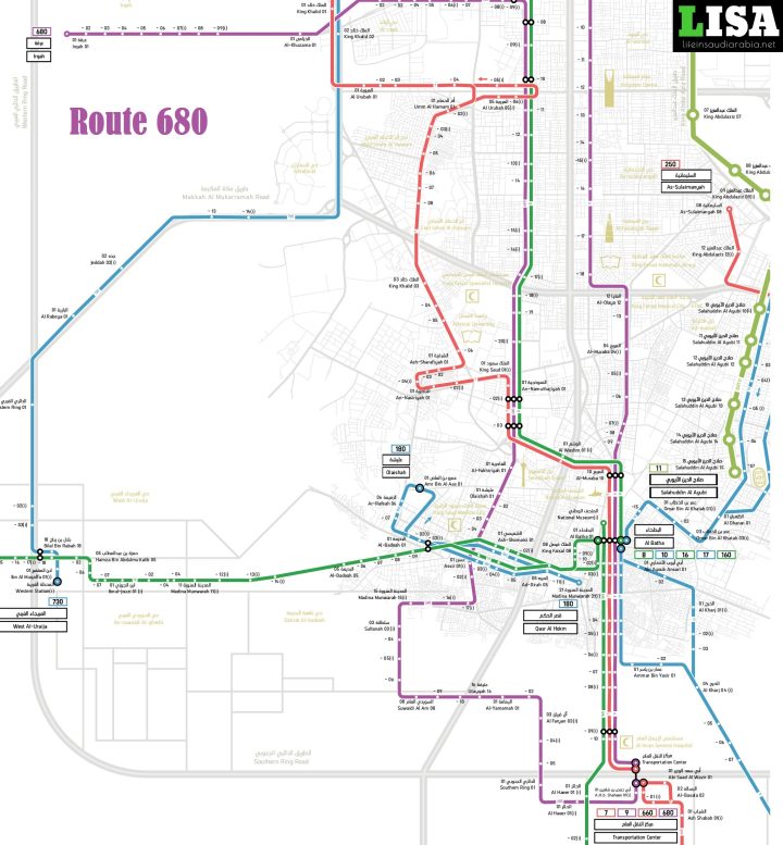
Route 680
Route 680 of Riyadh Metro City Bus connects Transportation Center to Irqah and takes the following major stops;
- Transportation Center ➜ Abi Hafs bin Shaheen Road ➜ Al Haer ➜ Southern Ring Road ➜ Central Vegetable and Fruit Market (Al Aziziyah) ➜ Al Faryan ➜ Al-Yamamah ➜ Utayqah ➜ Suwaidi Al Am ➜ Sultanah ➜ Assir ➜ King Saud Medical City ➜ Ulaisha ➜ Al-Fakhiriya ➜ An-Namuthajiyah ➜ Al Faisal University ➜ King Faisal Specialist Hospital ➜ Takhassusi ➜ King Abdullah Road ➜ King Abdulaziz City for Science and Technology (KACST) ➜ Ministry of Foreign Affairs ➜ Irqah.
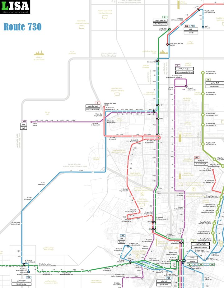
Route 730
Route 730 of Riyadh Metro City Bus connects West Al Uraija to Ar-Rabi and takes the following major stops;
- West Al Uraija ➜ Western Station ➜ Ibn Al Muqaffa ➜ Bilal Bin Rabah ➜ Western Ring Road ➜ Al Rabeya ➜ Jeddah Road ➜ Makkah Road ➜ King Khaled Road ➜ King Abdullah Road ➜ King Saud University ➜ Takhassusi ➜ King Abdullah Financial District ➜ Ath Thumamah ➜ King Abdulaziz Road ➜ Saudi Electronic University ➜ Ar-Rabi.
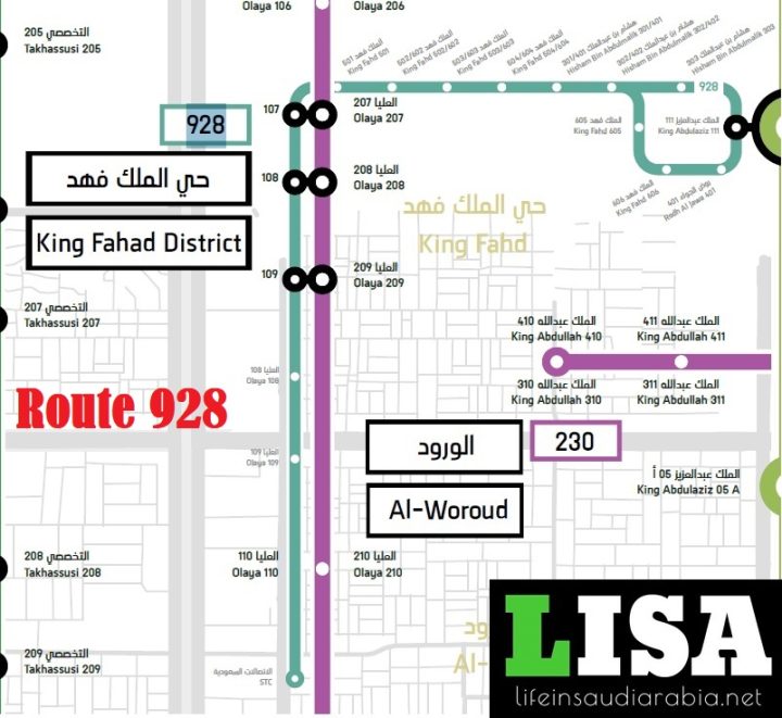
Route 928
Route 928 of Riyadh Metro City Bus connects Hisham Ibn Abd Al Malek to Kingdom Center and takes the following major stops;
- King Abdullah Road ➜ Taiba Markets ➜ Ministry of Municipal Rural Affairs ➜ Royal Mall ➜ Andulas Mall ➜ Kingdom Center.
Route 940
Route 940 of Riyadh Metro City Bus connects Abdulrahman Al Nasser street to Saybawiyyah and takes the following major stops;
- Abdulrahman Al Nasser street ➜ SASCO ➜ Riyadh Mall ➜ Rawdah Park ➜ Rawdah Muncipality ➜ Khazzan Al Rawdah Park ➜ Saybawiyya.
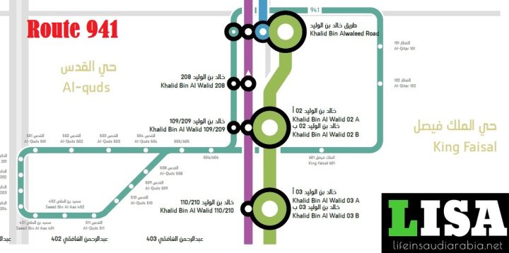
Route 941
Route 941 of Riyadh Metro City Bus connects King Faisal District to Al Quds district and takes the following major stops;
- Al-Qitar ➜ King Faisal ➜ Al-Quds ➜ Saeed Bin Al Aas ➜ Eastern Ring ➜ Riyadh Muncipality Club ➜ Al Sadhan Market ➜ Al-Quds.
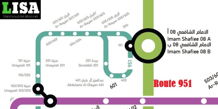
Route 951
Route 951 of Riyadh Metro City Bus connects Riyadh Care Hospital to Prince Muhammad bin AbdulAziz Hospital and takes the following major stops;
- Saudi Fransi Bank ➜ Prince Muhammad bin AbdulAziz Hospital ➜ Al Yamama Hospital ➜ Buraidah Walkway ➜ Tarbiyah Namouthajiyah Schools – Rayan ➜ Riyadh Care Hospital.
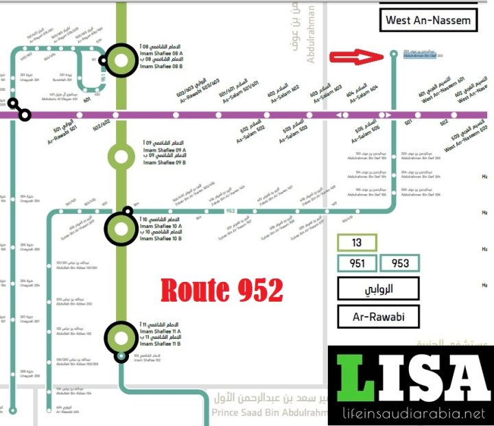
Route 952
Route 952 of Riyadh Metro City Bus connects Al Naseem Graveyard to Saudi Investment Bank and takes the following major stops;
- Abdulrahman Bin Owf ➜ Al Naseem Cemetry ➜ Zubair Bin Al-‘Awam ➜ Al Areej Park ➜ Al Sadhan Supermarket ➜ Romansia ➜ Abdullah Bin Abbas ➜ Saudi Investment Bank.
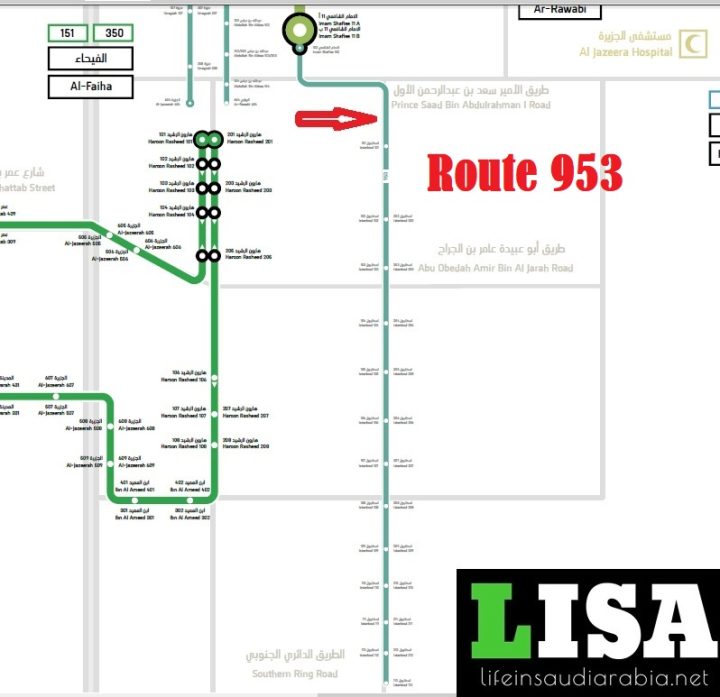
Route 953
Route 953 of Riyadh Metro City Bus connects Sky Mall to Multi Brands and takes the following major stops;
- Sky Mall ➜ Imam Al Shafi Street ➜ Istanbul Street ➜ Nadec Agricultural Company ➜ Al-Sulai Warehouses ➜ Multi Brands ➜ Southern Ring Road.
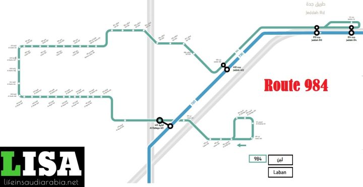
Route 984
Route 984 of Riyadh Metro City Bus connects Jeddah Road to Laban Street and takes the following major stops;
- Al Khadraa street ➜ Al Haweya ➜ Al Khafji Street ➜ Laban Street ➜ Al Remal street ➜ Al Shafa street ➜ Yanbu street ➜ Dahrat Laban Park ➜ Taif street ➜ Jeddah Street.
For the latest updates, you can join our ✅WhatsApp group or ☑️ Telegram Channel.


